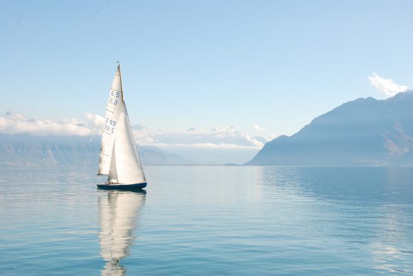
セイル(帆船)ドローンは、太陽光発電と風力発電によって自力航行できるように設計されたドローンです。
セイルドローンは約20フィート(約6m)の高さのカーボンファイバー製の帆を持ち、最高14ノットの速度で航行することができる上、計測機器を200ポンド(90kg)以上運ぶことができます。
また、セイルドローンには高度なセンサーパッケージが搭載されており、高精度な海洋データの収集が可能になります。
ほとんどの海洋調査では船舶による大規模な調査が必要となりますが、これには時間も人員も膨大に投入する必要があり、非常にコストが高くなるのが通例でした。
これに対して、セイルドローンは特定の研究ミッションに適した調査パターンを自動的に実行することができ、海域のデータを自律的かつコスト効率よく収集することができる上、収集されたデータは衛星通信経由でほぼリアルタイムに共有・参照できるようになります。
セイルドローンが収集したデータは、海洋についての理解を改めるだけでなく、気候変動、海洋酸性化、魚類の個体数把握などの課題を洞察するために重要であり、この惑星のすべての人に重大な影響をもたらすかもしれません。
Saildrones are Redefining the Collection of Ocean Data
Saildrone is an organization that designs and manufactures solar and wind powered autonomous surface vehicles. These small, self-navigating sailboats are mounted with advanced sensor packages, making the collection of cost-effective, high resolution ocean data possible at scale. Saildrone is busy in developing the world’s largest and high resolution datasets, working with private and government organizations around the globe. The firm believes that in planetary models, finer inputs yield finer outputs, and that the resulting insights will have a remarkable impact on our understanding of ocean fisheries, climate change, carbon cycling and weather forecasting.
The solar and wind-powered saildrone has a carbon fiber wing of about 20 feet high, and it speeds through the waters with the help of a suite of high resolution sensors. The saildrones are quickly maneuverable, can travel at speeds up to 14 knots and can carry over 200 pounds of instrumentation. There is also no need to continuously monitor or drive saildrones. A saildrone will continue on its path like a ship with a set course while taking measurements continuously and sending notice of potential dangers to on-shore engineers via satellite.
Fewer Ships and More Drones
Most ocean research requires ship time and this is highly expensive. As an alternative, the researcher can autonomously and cost-effectively gather data over huge ocean areas in any conditions by supplementing traditional ships with a fleet of saildrones. The saildrone is launched and retrieved from a dock and navigates to its destination using only wind power, transiting at 3-5 kts. The drone can then perform survey patterns that are best suited for the particular research mission or hold station.
Real-time Data
The data belonging to a specific research mission is transmitted back toshore by satellite and delivered seamlessly through Saildrone’s API. The client portal of Saildrone can be accessed on any tablet/smartphone or computer for the visualization and manipulation of live data.
Custom sensors
The engineers at Saildrone have incorporated a suite of sensors into the saildrone that include dissolved oxygen, salinity, flourescence, water temperature, ocean surface temperature, barometer, air humidity, air temperature and wind. Also, the engineers are working on additional technologies like carbon dioxide-methane sensor for measuring the gas exchange between water and air and an acoustic fish finder for examining fish populations.
What does a Saildrone measure?
Saildrones measure their position(longitude and latitude), oceanic parameters(ocean surface current, dissolved colored organic matter, magnetic field strength, salinity, water temperature, dissolved oxygen concentration, chlorophyll-a concentration, and red-light backscatter) and atmospheric parameters(sunlight, relative humidity, air temperature, wind and barometric pressure) and report them via an Iridium satellite data link.
What does this data reveal?
The position data enables scientists to plot measurements on a map. The wind pressure and barometric pressure are indicators of mixing of the upper layers of oceans and storms as well as foul or fair weather that affects the sailing conditions of saildrone. Humidity and air temperature tell whether it is cold or warm, perhaps owing to the proximity of sea ice – saildrones must stay away from this to avoid hull damage. The energy is provided by sunlight to top-up saildrone batteries and to grow phytoplankton or microscopic plants – the basis of oceanic food web. The satellite measurements that can deduce the ocean properties can be calibrated by the amount of sunlight that is scattered back to the sky in the red color band. The resulting measurement of chlorophyll-a concentration is a measure of the amount of phytoplankton present.
The dissolved oxygen concentration measures the ability of phytoplankton to change inorganic material – carbon dioxide and nutrients – into plant biomass consumed and passed up the food web to larger animals that include fish, crab, whales, zooplankton and humans. The water salinity and temperature govern the oceanic ecosystem’s basic physical conditions. CDOM (colored dissolved organic matter) is a tracer of river water that has entered the ocean. The ocean currents transport passive plankton along with water to new locales. The magnetic field signatures give insight into the variations in the magnetic field of the earth and provide information on seafloor spreading.
Conclusion
Saildrones have the capability to increase observational infrastructure in hostile and remote polar regions where human labor and ship time is potentially hazardous and costly. The data gathered by saildrones will not only change the understanding of our oceans but will also bring insight into issues such as climate change, ocean acidification, fish populations and weather – and every person on this planet will be affected by these processes.